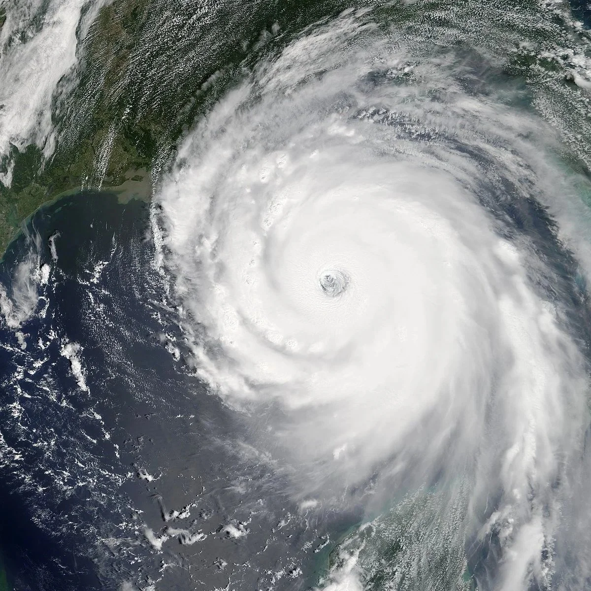
Tropical Storm Arthur Causes Estimated $112 Million in Losses for Louisiana Farmers
Louisiana farmers suffered an estimated $112 million loss as a result of Tropical Storm Arthur last month. Avoyelles, St. Landry and Rapides Parishes accounted for 90% of total losses. Agriculture Commissioner Mike Strain says Avoyelles received 29 inches of rain in less than 24 hours.
Read More
USDA Raises Cattle Price Outlook as Tight Supplies and Drought Slow Herd Rebuild
The U.S. Department of Agriculture (USDA) is forecasting continued strength in cattle prices after lowering its beef production outlook and raising steer price projections through 2027.
Read More
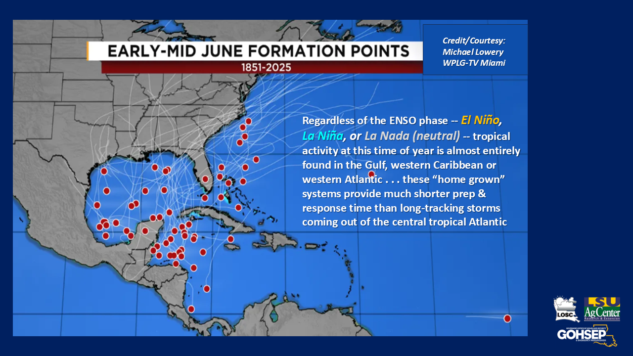
Colorado State University Reduces Forecast For Atlantic Hurricane Season
As the summer weather heats up, forecasters have a bit of good news about hurricane season.
Colorado State University has reduced the amount of expected tropical systems for the Atlantic Hurricane Season.
Read More
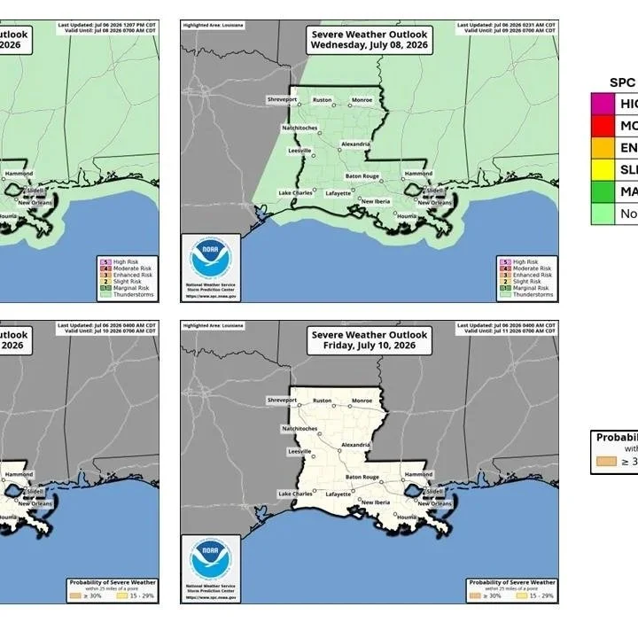
July 7-12 Weather Outlook
A summer pattern of 'hot 'n humid' will be the rule for all of Louisiana through the upcoming 7 days. Scattered to numerous showers and t-storms are in the forecast for Tuesday but it turns drier (and a little hotter) for most communities (especially the northern half of the state) after Tuesday and into the weekend.
Read More
Trump Approves Disaster Request For Arthur
President Donald Trump last week approved Louisiana’s request for $8.6 million in federal aid for the damage caused by Tropical Storm Arthur last month.
The storm dumped record rainfall on Avoyelles Parish and the surrounding areas, causing widespread flooding. It also generated numerous tornadoes across southeast Louisiana.
Read More
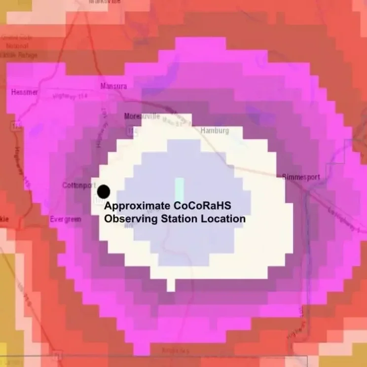
24-Hour Rainfall Record In Louisiana Broken
Our neighbors north of Acadiana are still recovering after record rainfall fell during the remnants of Tropical Storm Arthur.
Hundreds of homes were flooded in parts of central Louisiana, and many had to be rescued by emergency officials as the water rose so quickly.
Read More
Deer Herd Escapes To Higher Ground To Escape Flooding
Tropical Storm Arthur dropped historical amounts of rain causing dangerous and destructive flooding in parts of Louisiana, prompting Gov. Jeff Landry to declare a state of emergency for Avoyelles, Lafourche, Pointe Coupee, St. Landry, St. Tammany, and Terrebonne parishes.
Read More
Arthur's Short Tropical Life Will Still Produce Significant Rains
The threat for active storms is not over for Louisiana ... but concerns for any widespread severe weather and tropical impacts are on a slow decline for the Bayou State.
Arthur appears to have already moved inland and is expected to remain inland for the rest of 'his' brief journey.
Read More
Missouri River Runoff Forecast Continues Below-Average
Dry conditions across the Missouri River Basin are continuing to reduce runoff and raise concerns about water supplies and navigation later this year.
Read More
May Rains Ease Drought Conditions
May's rains have brought significant relief to Louisiana's drought conditions, which peaked in severity and coverage during April after months of dry weather tied to La Niña. Much of the state has seen noticeable improvement thanks to a wetter-than-normal May, and early indications suggest the rainfall arrived just in time to benefit many agricultural producers. However, the full impact remains to be seen, particularly in northwestern Louisiana, where drought conditions have been slower to improve.
Read More
Does El Niño mean another 'quiet' Hurricane Season for the Bayou State?
El Niño is expected to develop during this year’s hurricane season, and while El Niño years typically produce fewer storms across the Atlantic and generally lower the risk for Louisiana, it does not eliminate the threat of tropical weather.
Read More
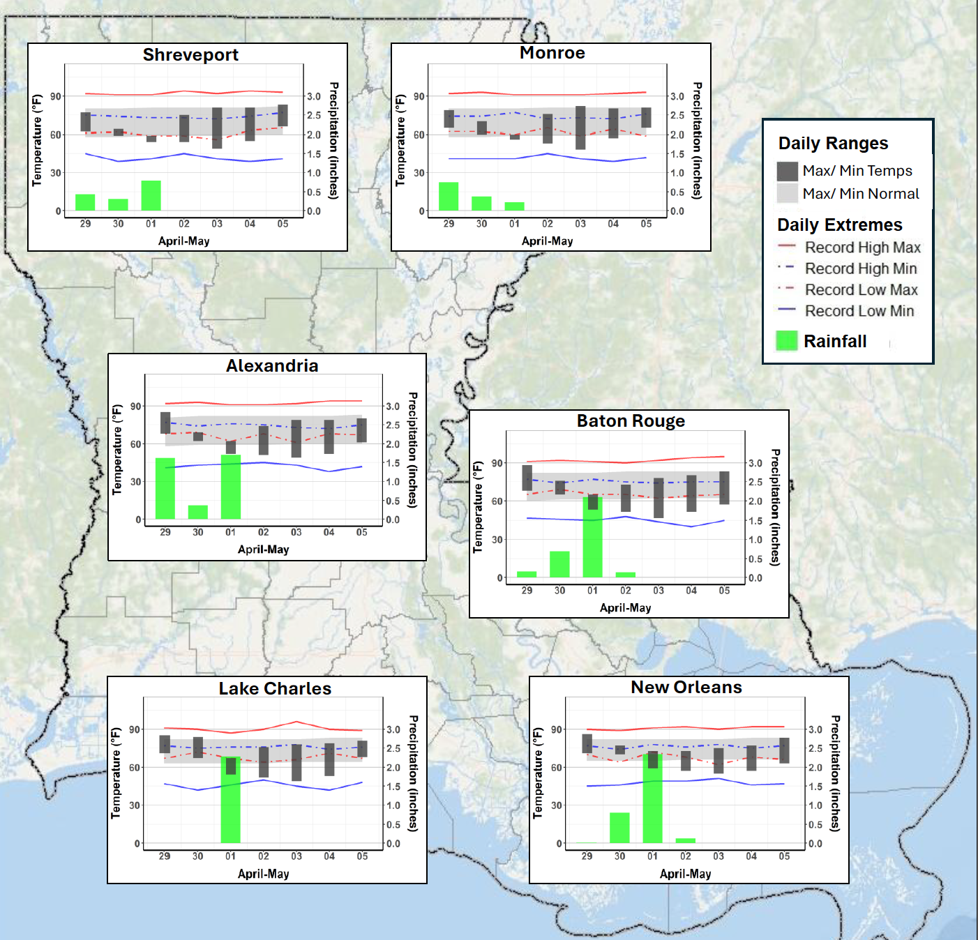
Louisiana Weekly Climate Summary - April 29- May 5, 2026
Louisiana saw a wet and active week, with widespread rainfall and several rounds of severe weather as a slow-moving front crossed the state. Rain totals were above normal across most of Louisiana, especially in central and southeastern areas.
Read More
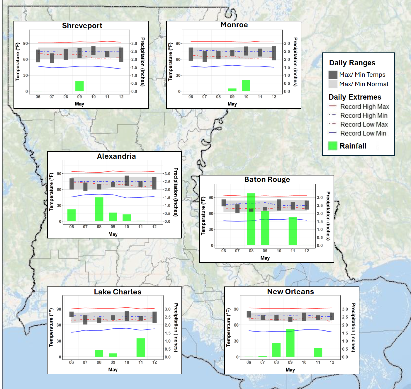
Louisiana Weekly Climate Summary - May 6–12, 2026
Louisiana experienced a wet and stormy week, with multiple rounds of showers and thunderstorms bringing heavy rain, flash flooding, and severe weather to much of the state. Nearly 60 weather warnings were issued, including tornado, severe thunderstorm, and flash flood warnings. A brief tornado touchdown was confirmed in St. James Parish.
Read More
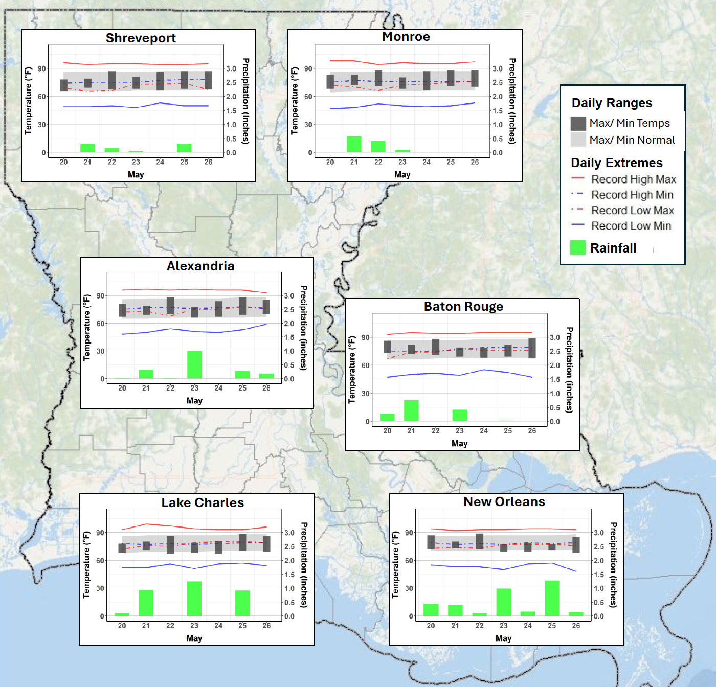
Louisiana Weekly Climate Summary - May 20–26, 2026
Louisiana saw another wet and active week, with repeated rounds of rain and thunderstorms helping improve drought conditions across much of the state while also causing localized flooding.
Read More
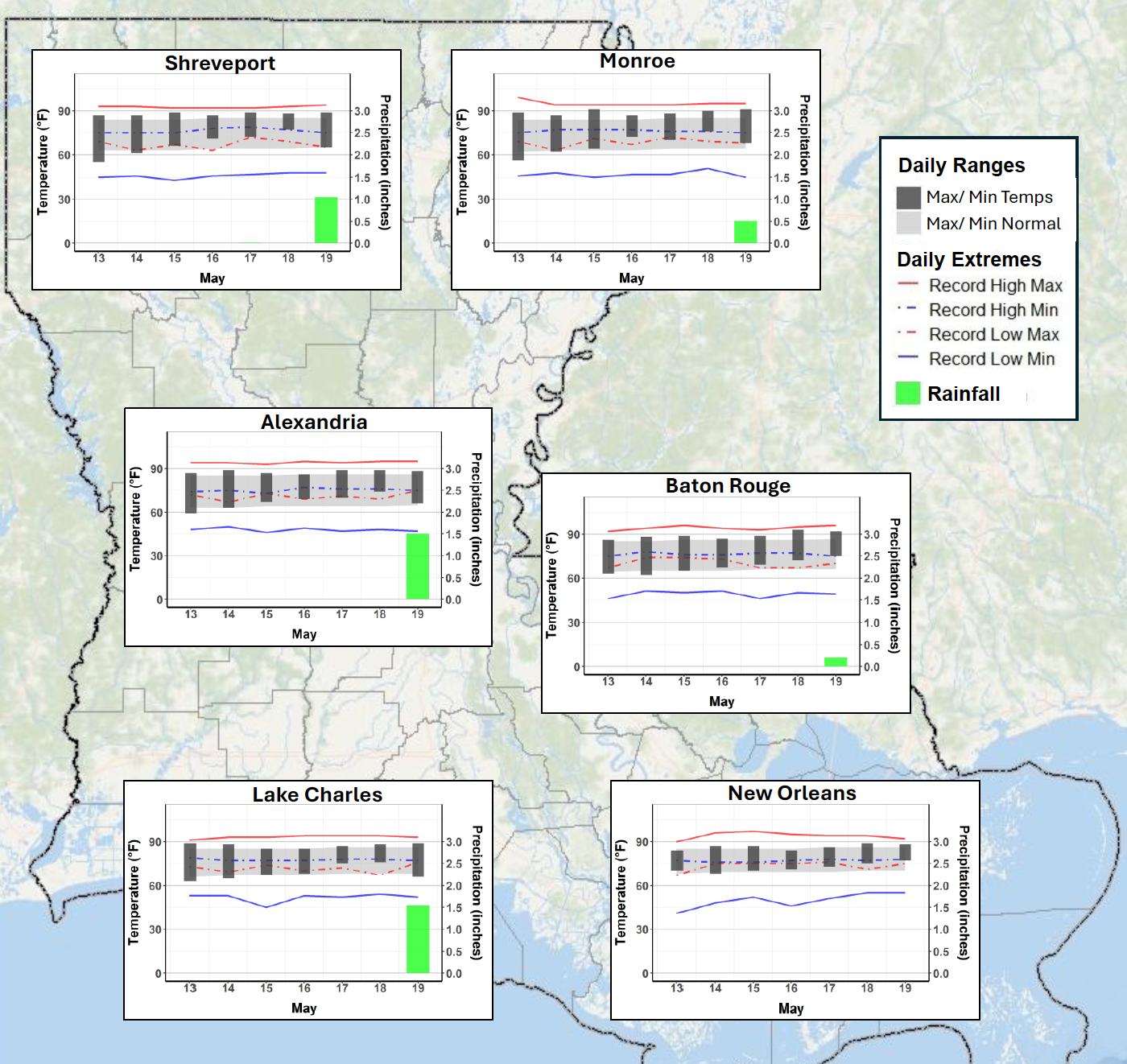
Louisiana Weekly Climate Summary - May 13–19, 2026
Drought conditions improved across parts of southern Louisiana thanks to recent rains, but northern Louisiana continued to dry out. More than 75% of the state remains in drought, with Extreme Drought expanding across northern parishes.
Read More