
Arctic Front Delivers Brutally Cold Weekend
By Jay Grymes
State Climatologist
Sunday Evening:
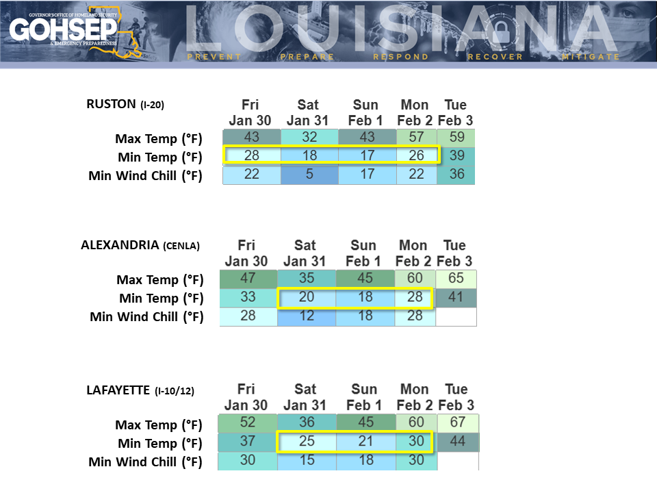
Most of Louisiana "warmed" to the 40°s by 1:00 PM on Sunday with afternoon highs reaching the mid to upper 40°s to low 50°s statewide.
Most of the state can expect another freeze for tonight into Monday morning (Feb 2), although minimum temperatures won't get nearly as low as the past two mornings. Plan for upper 20°s for most of the northern half of the state and the Florida Parishes, with low 30°s for most of the remaining parishes. Freeze durations could run as much as 12 hours for some northernmost parishes but will be brief along and below the I-10. Coastal communities may miss out on a morning freeze altogether.
Expect highs in the 60°s for Monday (Feb 2) and Tuesday (Feb 3).
Louisiana's next cold front moves qcross the state between Tuesday and Wednesday. The front will bring rain and a few t-storms but severe weather is not expected. The NWS Weather Prediction Center (WPC) has lowered its forecasted rain amounts for the two days to less than 0.5" statewide.
The air mass behind that mid-week front will not be nearly as cold as the last two Arctic frontal passages. Still, most northern and central parishes should plan for a brief freeze on Thursday morning (Feb 5). High temperatures will get into the 50°s statewide for Wednesday (Feb 4) and Thursday (Feb 5), and into the 60°s statewide for Friday (Feb 6) and Saturday (Feb 7).
Sunday Morning:
This morning should be the end of the bitterly-cold Arctic air ... but expect another freeze for Monday morning. Sunday (Feb 1) highs should reach the 40°s to near 50° under partly cloudy to mostly sunny skies ... a welcomed warm-up. Expect highs in the 60°s for Monday (Feb 2) and Tuesday (Feb 3).
Louisiana's next cold arrives Tuesday/Wednesday, bringing rain and a few t-storms. Severe weather is not expected, and the NWS Weather Prediction Center (WPC) has lowered its forecasted rain amounts to less than 1" statewide.
The air mass behind the mid-week front will be a Pacific air mass rather than of Arctic origins and therefore not nearly as cold as the past few days. Northern and central parishes could see another round of brief freezes for Thursday morning (Feb 5) but daytime highs should get into the 50°s statewide for Wednesday (Feb 4) and Thursday (Feb 5).
![Slide2[95].PNG](https://images.squarespace-cdn.com/content/v1/55f2e952e4b0ef7e0849a5a3/1769971375161-6WYYCWZSOQLZTO364AP7/Slide2%5B95%5D.PNG)
![Slide1[24].PNG](https://images.squarespace-cdn.com/content/v1/55f2e952e4b0ef7e0849a5a3/1769971372874-C1QKD07QRRL6U11QUG9R/Slide1%5B24%5D.PNG)
![Slide3[42].PNG](https://images.squarespace-cdn.com/content/v1/55f2e952e4b0ef7e0849a5a3/1769971375531-ID4WP4PE6ZK1CNPN4MNY/Slide3%5B42%5D.PNG)
![Slide4[2].PNG](https://images.squarespace-cdn.com/content/v1/55f2e952e4b0ef7e0849a5a3/1769971376679-1K5L8D0XIKCEFTJK6PHY/Slide4%5B2%5D.PNG)
![Slide5[50].PNG](https://images.squarespace-cdn.com/content/v1/55f2e952e4b0ef7e0849a5a3/1769971377935-CXARDMLPSIM9T6KF8KYC/Slide5%5B50%5D.PNG)
![Slide6[52].PNG](https://images.squarespace-cdn.com/content/v1/55f2e952e4b0ef7e0849a5a3/1769971379508-CBNVLA8PD4E1ZLEEJO3M/Slide6%5B52%5D.PNG)
Saturday Morning:
Be mindful that we've had NINE weather-related fatalities (at least) in Louisiana thus far with another bitterly-cold night ahead.
GOHSEP has received reports of snow falling in Waterproof & Newellton (both in Tensas Parish) this Saturday morning (Jan 31) ... "confirmed" by NWS/Jackson radar (graphic attached)! Not expecting any meaningful accumulations but with the cold ground and surfaces, I wouldn't be surprised to hear of some of it sticking around for a while.
Temperatures and wind chills may not have gotten quite as cold for Saturday morning as forecasted ... but the difference was only 1° to 2°. That still made for a brutally-cold start to the day. Expect mainly sunny skies statewide for Saturday and the brisk winds will subside a bit from the morning into the afternoon. Temperatures may not get above freezing for a number of northern communities and Saturday afternoon temperatures will only hit the mid to upper 30°s along much of the I-10/12.
Sunday (Feb 1) opens with upper 'teens to low 20°s for low temperatures across the northern half of Louisiana with low to mid 20°s along the I-10/12 corridor. Sunday morning winds should be a bit lighter but minimum wind chills will still drop into the 'teens and low 20°s for most of the state. Fortunately, afternoon highs should reach the mid to upper 40°s statewide. Morning sunshine will give way to increasing clouds for the afternoon and into the evening.
Can't say it enough: this is dangerously cold air. Be extra careful with the supplemental heaters and thoe portable generators. And for the brave souls headed to area parades this weekend (parade-goers and krewes), make sure to dress in layers!
Expect another freeze for Monday morning (Feb 2, Groundhog Day) but afternoon highs are expected to reach the 60°s for most parishes.
The NWS Weather Prediction Center continues to show rain returning to Louisiana in associaton with the next cold front. Rains are expected to begin over the NW parishes on Tuesday (Feb 3) and advance to the SE parishes through Wednesday (Feb 4). The latest WPC projections call for 1" or less statewide over the 2-day run.
Northern and central parishes could see a pair of light, relatively brief morning freezes on Thursday (Feb 5) and Friday (Feb 6) behind next week's front, but nothing as cold as our two recent Arctic blasts.
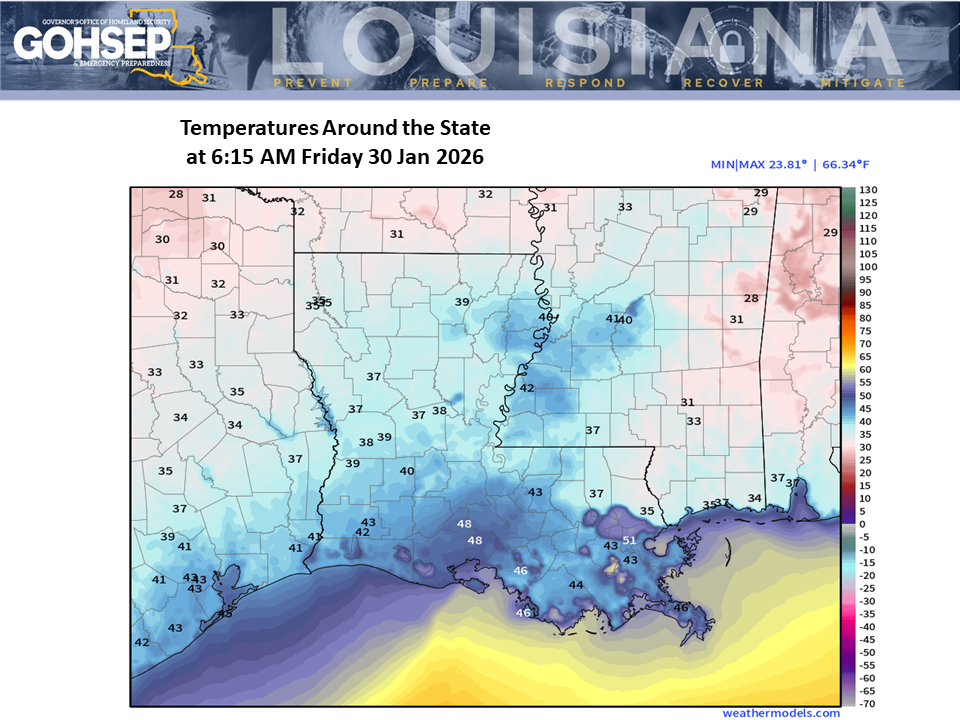
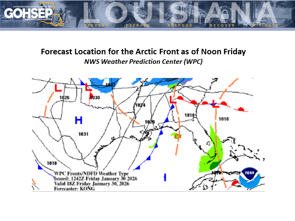
Friday Morning:
An Arctic front is moving through southeast Louisiana this morning. Temperatures around the state are currently above freezing but will drop below 32° for many parishes before midnight tonight.
The full effects of the Arctic air mass arrive statewide before sun-up on Saturday morning (31 Jan 2026): bitterly-cold air will be augmented by northerly winds in the 10-20 mph range, pushing wind chills down into the single-digits for most northern parishes.
The Arctic air is too dry to produce any meaningful winter precipitation although a few flakes and light flurries can’t be ruled-out over north Louisiana. Accumulations are not expected.
Weekend parade-goers and krewes need to prepare for the extra-cold weekend air.
Temperatures will struggle to get above freezing over much of northern Louisiana on Saturday with highs only reaching the mid to upper 30°s for most of the remaining parishes. Fortunately, winds should subside somewhat into Saturday afternoon and evening.
The Arctic air remains in place into Sunday (1 Feb 2026) for another brutally-cold morning, and much of the state can expect another freeze for Monday morning (2 Feb 2026) before temperature begin to moderate next week.
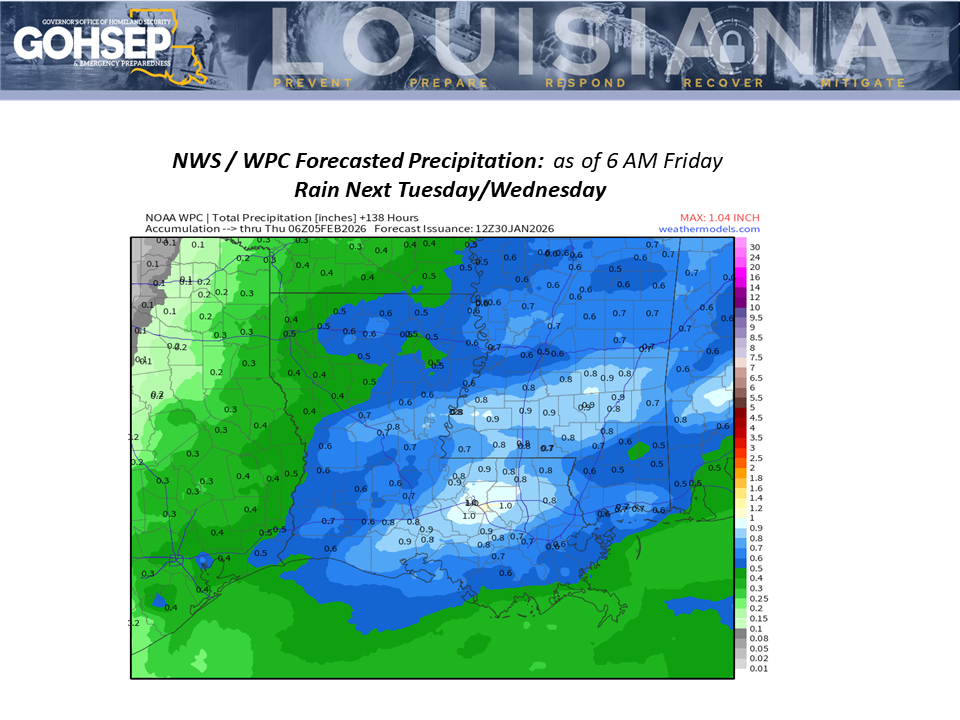
The NWS Weather Prediction Center calls for the next meaningful rains to arrive on Tuesday into Wednesday (3-4 Feb 2026).
The extended outlook keeps continues with a cooler-than-normal trend into Carnival weekend.
Thanks:
Local NWS offices serving Louisiana: SHV, JAN, LCH & LIX
NWS Weather Prediction Center (WPC)
NWS Climate Prediction Center (WPC)
PowerOutage.com
WeatherModels.com
GOHSEP & LSU