
Louisiana Weekly Climate Summary -- November 05 – November 11, 2025
By Jay Grymes
Louisiana State Climatologist
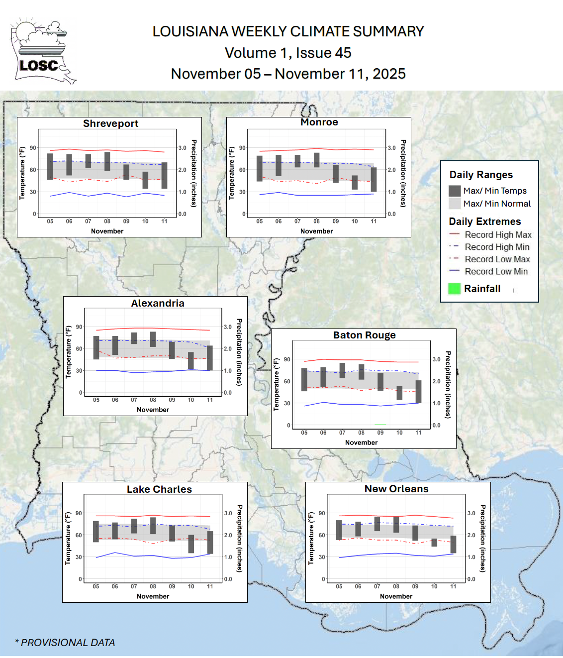
Most of the Bayou State didn’t receive any precipitation during the 7-day period; the exception was mainly over southeastern and south-central portions of the state during the frontal passage of Nov 8-9.
The period began with significantly above-normal temperatures across Louisiana with some stations reporting near-record to record high temperatures
Temperatures dropped markedly following the cold front passage of Nov 8-9 as the first freeze of the season prompted NWS Freeze Warnings for most parishes on the morning of Nov 11th; a number of locations around the state reporting near-record to record lows that morning
The Drought Monitor depiction for Louisiana showed degradations, with expansions of D1 (‘Moderate Drought’) and D0 (‘Abnormally Dry’) areas and the introduction of D2 (‘Severe Drought’) centered on Natchitoches Parish and portions of Acadiana.
With the changes, D1 extends across nearly 22% of the Bayou State; D0 covers 50%, and D2 covers just over 2%; it’s the first time D2 has appeared in the state since 12/24/24
Most of the state received no precipitation during the 7-days … that coupled with above normal temperatures during the first portion of the period and windy conditions following a frontal passage (Nov 8-9) increased evapo-transpiration (ET) above seasonal norms
The NWS issued Red Flag Warnings across south Louisiana on Nov 10th in response to the dry conditions combined with low humidity and gusty winds (p. 4)
As of Nov 12th, LSU AgCenter agents noted “Very Dry” conditions across 11 parishes with more than half of the state assessed as “Dry” to “Very Dry”
5 parishes currently have Burn Bans as of this summary: Acadia, Allen, De Soto, Evangeline, and Jeff Davis
as of this summary, Parish Fire Danger Levels are posted as “Very High” for 7 parishes, “High” for 8 parishes, “Medium” for 7 parishes and “Low” for the remaining
The relatively quiet pattern meant no threats of severe weather during the 7-day period. However, the NWS did issue Red Flag Warnings across the southern half of the state on Nov 10th in response to the dry and breezy conditions behind the Nov 8-9 cold front. Red Flag Warnings reflect an increased risk of fire danger and spread.